

Our drone-based 3D scanning service combines photogrammetry and LiDAR to deliver precise digital models for engineering and public works teams. Our geomatics engineer, technician, and land surveyor teams convert raw data into diagnostics and actionable plans for projects across Québec.
Our data acquisition and analysis services:
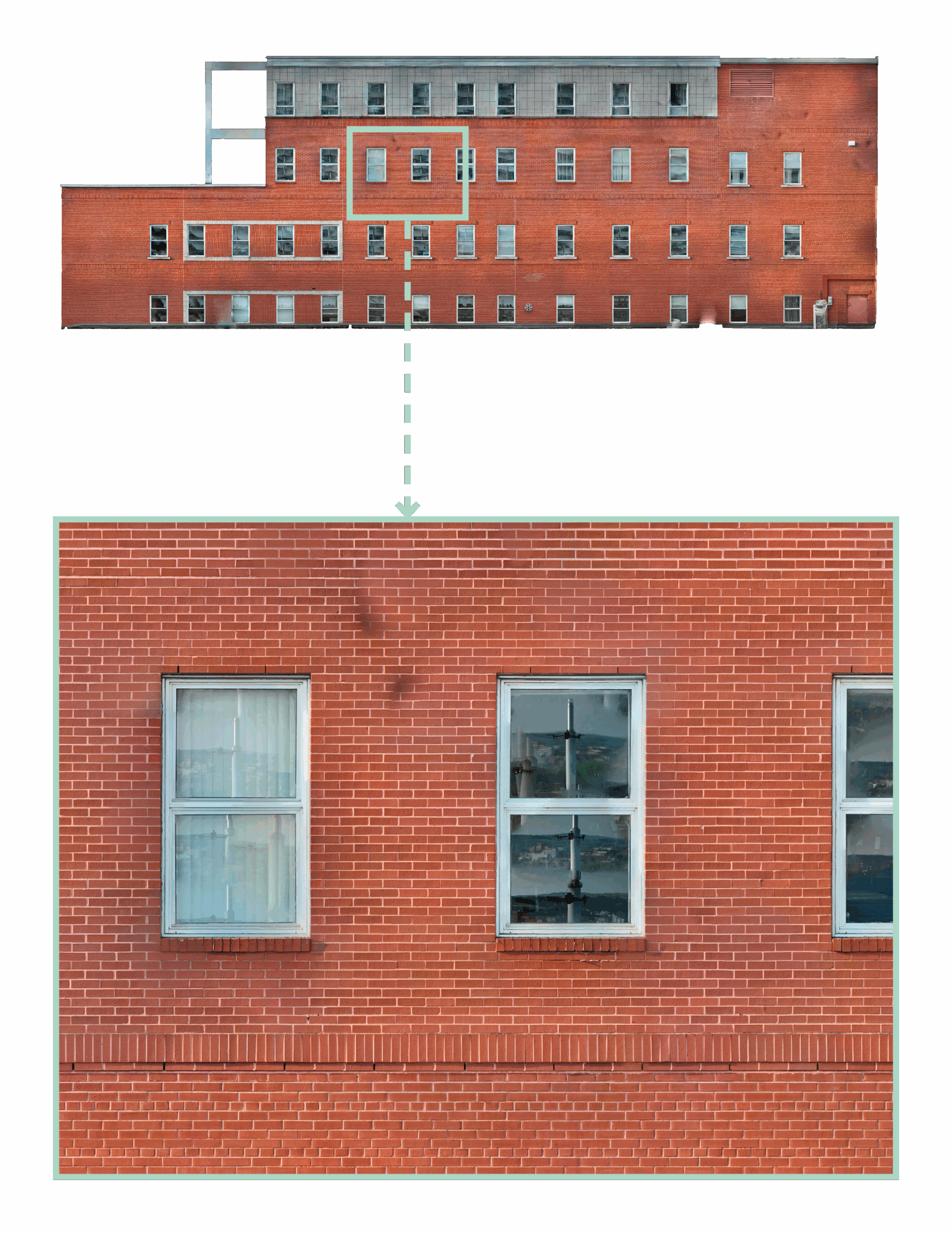
Vertical façade orthophotos – Bill 122 inspections
Drone photogrammetry transforms how façade inspections are performed under Bill 122. Our georeferenced vertical orthophotos document structural conditions with accuracy. Each image is rectified to scale, offering a reliable base for locating, measuring, and tracking deterioration.
Certified reports and compliance
Technical reports can be produced and signed by our engineers in accordance with requirements from the Régie du bâtiment du Québec (RBQ – licence 5718-4566-01).
Turnkey service
Can-Explore manages the entire process (surveying, orthophotos, 3D modeling, analysis, and reporting) with no subcontracting. A complete, compliant, and efficient solution for façade inspections.
Construction site monitoring
Keep your construction and development projects on schedule and aligned with plans.
- Quality control: Photogrammetry generates orthophotos and 3D models to compare current site conditions with design plans, enabling early detection of deviations or non‑conformities
- Legal documentation: Certified reports from our land surveyors provide essential proof for billing and dispute resolution
For more information, visit our construction monitoring page.
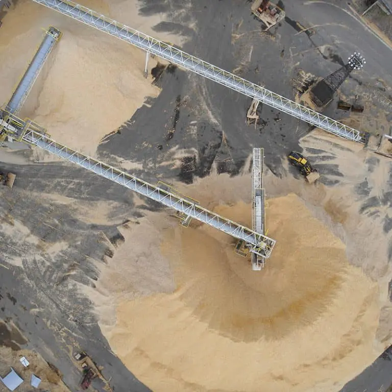
Volumetric calculations – Quarries and sand pits
For quarries, sand pits, and aggregate sites, drone photogrammetry is the most efficient tool for periodic inventories.
- Fiscal and regulatory measurement: Accurate volumetric calculations for quantity tracking and verification of fiscal and regulatory compliance required by regional county municipalities
- Planning: 3D modeling provides high‑accuracy data for earthwork monitoring, residue management, and future site planning
Visit our volumetric surveying page for more information.
Precision inspection and diagnostics for civil structures
We provide critical data for:
- Inspection and assessment of bridges, overpasses, and other civil structures;
- Identification of structural remnants or property boundary analysis (rights-of-way, easements);
- Monitoring shoreline conditions and sensitive zones for environmental management and natural risk prevention.
Deliverables and Software Integration
We provide deliverables ready for direct use in your workflows.
| Deliverable Type | Description & Key Benefit | Compatible Software |
|---|---|---|
| Point Cloud (colorized) | 3D representation of the environment or asset, the basis for all measurements. | Autodesk (Recap, Revit, Civil3D), Collada, VRML, etc. |
| Orthophotography (orthophotos or orthomosaics) | Rectified and scaled aerial images. | GIS software (ArcGIS, QGIS); Autodesk (Recap, Revit, Civil3D) |
| Digital Surface Model (DSM/DTM) | Altimetric representation of the terrain. | GIS and CAD software |
| Textured 3D Models | Realistic models for communication, urban planning, and project presentation. | Industry standard formats |
Acquisition Technology: Photogrammetry and LiDAR
Photogrammetry and LiDAR each offer distinct strengths. We combine them for optimal results: LiDAR versatility and photogrammetric photorealism.
WingtraOne GEN II from Wingtra
The WingtraOne GEN II is an advanced, intelligent mapping drone that delivers unmatched performance for surveying large sites (photogrammetry). This drone maximizes coverage in a single flight, capable of covering up to 460 hectares in one hour, optimizing surveying operations by reducing labor hours. With its VTOL design (vertical takeoff and landing), it performs exceptionally well on vegetation‑free terrain. The WingtraOne GEN II is equipped with a 61 MP camera, providing the highest‑quality imagery with an absolute horizontal accuracy of less than one centimeter.
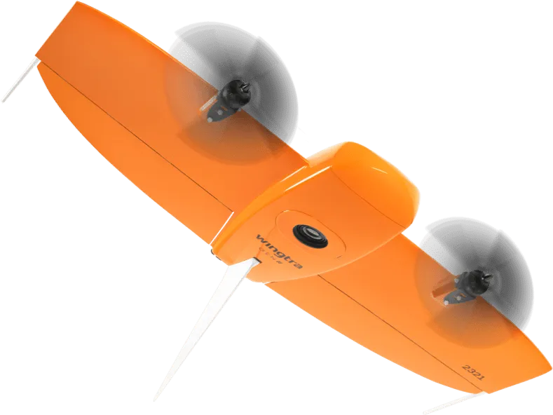
Image from Wingtra.
Leica Pegasus TRK 700 Neo
The Leica Pegasus TRK 700 Neo is a state‑of‑the‑art mobile mapping tool capable of capturing more than one million LiDAR points per second. Powered by artificial intelligence, it is the ideal solution for rapid surveying of long roadway segments. With integrated SLAM (Simultaneous Localization and Mapping) and high‑precision RTK (Real Time Kinematics) positioning, this system georeferences geospatial data with centimeter‑level accuracy. Its built‑in cameras with ISOFIX finally allow RGB photo colorization to be applied to the point clouds collected by its LiDAR scanner.
Image from Leica Geosystems.
NavVis MLX from NavVis
The NavVis MLX transforms 3D reality capture with its advanced, portable technology. Its compact and ergonomic design offers unmatched mobility for surveyors, making it ideal for quickly and efficiently scanning the interior of a building or structure. With its 32‑layer LiDAR sensor combined with SLAM (Simultaneous Localization and Mapping) software, this system delivers the highest point‑cloud quality among comparable tools. Finally, its four integrated cameras capture high‑resolution 360º images, enabling RGB photo colorization to be applied to the point clouds collected by its LiDAR scanner.
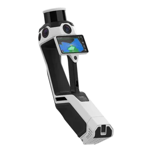
Image from NavVis.
Ask for a Quote – Photogrammetry:
Any questions? A specific project in mind?
Don’t hesitate to contact us. Our solutions are tailored to your needs.